Ultimate Weather Radar Applications for Outdoor Enthusiasts & Daily Safety
A weather radar application is your ultimate shield against unpredictable storms, severe rain, and sudden weather shifts. With over 90% accuracy in real-time tracking, live Doppler data helps outdoor enthusiasts, drivers, and adventurers stay one step ahead of nature's surprises. Discover how radar tools keep you safe, and explore the best ways to plan your next journey!
Master your trips with a weather radar application
Why Weather Radar is Essential for Outdoor Enthusiasts
Checking a standard daily forecast tells you if it might rain today. However, it will not tell you if a storm is hitting your exact trail in twenty minutes.
That is where a live weather radar application becomes a game-changer for outdoor lovers.
By delivering real-time atmospheric data directly to your screen, radar technology bridges the gap between general forecasts and precise location safety.
Here is why every adventurer needs real-time radar on their radar:
-
Real-Time Short-Term Forecasting: Standard forecasts update every few hours, but nowcasting updates every few minutes. You can track shifting clouds within a 1-to-6-hour window, giving you enough time to adjust plans before the first drop falls.
-
Precision Storm & Precipitation Tracking: Radar maps show you exactly where precipitation is forming, how heavy it is, and which direction it is moving. You can watch rain intensity levels shift in real time rather than guessing.
-
Safety & Hazard Avoidance: Severe weather can develop without warning. Live radar helps you spot approaching lightning strikes, sudden flash flood risks, high wind gusts, and severe thunderstorms long before they reach your location.
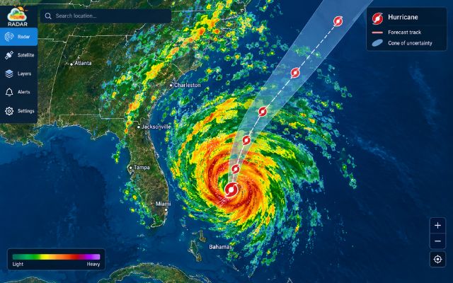
Weather radar is essential for hazard avoidance
Key Weather Radar Application in Outdoor & Daily Activities
Whether you are scaling a mountain peak, launching a boat, or taking a weekend road trip, weather radar provides tailored benefits for almost any activity.
Here is how different outdoor enthusiasts use radar mapping to stay safe and make the most of their time outside.
1. Weather Radar for Hiking & Trekking
Mountain weather changes rapidly. A sunny morning can turn into a heavy downpour within minutes. Using radar allows hikers to monitor convective cloud development over high elevations.
This early insight helps you avoid dangerous rockslides, swollen river crossings, and sudden drops in body temperature caused by wet gear.
Continue reading: Learn more about using weather radar for hiking
2. Weather Radar for Fishing
Fish behavior is deeply tied to barometric pressure shifts and incoming rain fronts.
Anglers use weather radar to identify active feeding zones created by light surface rainfall.
More importantly, live tracking helps fishermen spot approaching offshore storms early enough to retrace their steps or head back to the dock safely.
Continue reading: Explore weather radar guide for anglers & fishing
3. Weather Radar for Boating & Sailing
Open water offers zero shelter when severe weather hits. Skippers and sailors rely on Doppler radar to detect wind squalls, waterspouts, and heavy rain cells miles away.
Tracking wind vector overlays alongside precipitation layers ensures smooth navigation and keeps your crew well out of harm's way.
Continue reading: Weather radar for boating
4. Weather Radar for Camping & Backpacking
Nothing ruins a camping trip faster than a flooded tent or soaked sleeping bag.
Checking radar layers helps campers select high, dry campsites away from dry creek beds that could flash flood overnight.
It also gives you plenty of lead time to pitch tarps, secure camp gear, or decide if it is time to evacuate.
Continue reading: Complete guide to weather radar for camping
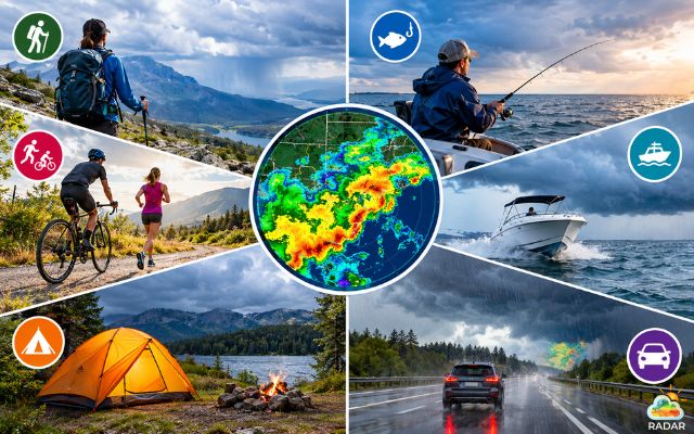
Top weather radar application for safety outdoor activities
5. Weather Radar for Cycling & Running
Rain does not have to cancel your workout. Cyclists and runners use radar maps to find "rain gaps" - pockets of clear weather between moving storm cells.
By tracking rain movement frame-by-frame, you can fine-tune your route, avoid slick road surfaces, and complete your training completely dry.
Continue reading:
- Weather radar for outdoor running
- Weather radar for cycling
6. Weather Radar for Driving & Road Trips
Highway driving during heavy downpours or icy winter storms severely cuts down visibility and traction. Drivers can use radar tools to preview route conditions ahead.
Spotting severe weather cells early allows you to pull over safely, choose a clearer detour, or postpone high-speed driving until conditions improve.
Continue reading: Explore weather radar for driving
How Weather Radar Works for Outdoor Safety
When you look at a radar map on your phone, you are viewing high-tech atmospheric scanning simplified for fast reading.
Here is how weather radar translates invisible sky signals into easy-to-read safety maps:
-
Doppler Effect in Action: Radar towers send out radio waves into the atmosphere. When these waves bounce off raindrops, hail, or snow, they return to the sensor. By measuring how the frequency changes, the system calculates whether precipitation is moving toward you or pushing away.
-
Reflectivity Scale (dBZ): Radar maps use color coding to measure storm intensity in decibels of Z (dBZ). Light green indicates faint drizzles (around 20 dBZ), while bright yellow and dark red signal heavy downpours or hail storms (50+ dBZ). Deep purple usually warns of severe thunderheads or tornado risks.
-
Radar Coverage & Terrain Blind Spots: Radar waves travel in straight lines, but the Earth is curved. High mountain ranges or deep valleys can block radar beams, creating "blind spots." Knowing this helps outdoor lovers cross-reference radar data with local satellite views when trekking in steep terrain.
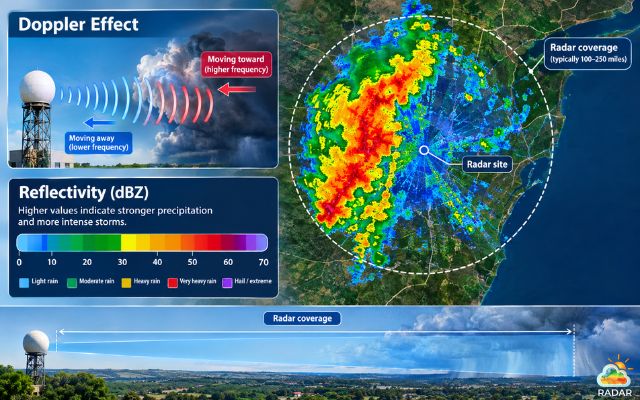
Weather radar combines the Doppler effect, dBZ, and radar coverage
How to Choose the Right Weather Radar Platforms
Not all weather platforms are built for active outdoor use.
When you are out in the field, you need a responsive tool that delivers fast, accurate data without clogging your mobile screen.
That is exactly why millions of adventurers rely on GoWeatherRadar.
Here is what makes GoWeatherRadar the ideal choice for your outdoor trips:
-
Interactive Live Radar Maps: Effortlessly zoom in on your exact trail, lake, or camping spot. You can layer multiple datasets, including precipitation, wind vectors, ambient temperature, and sea-level pressure - all on one smooth map interface.
-
High-Precision Nowcasting: Weather changes in seconds, and so does GoWeatherRadar. Live feed updates refresh constantly, delivering second-by-second tracking so you can react before the rain starts falling.
-
Custom Severe Alerts & GPS Location Tracking: Enable live GPS tracking to receive automated pop-up alerts for lightning, flash floods, or high winds heading directly toward your current location.
-
User-Friendly Mobile Experience: Designed to be lightweight and fast, the platform loads seamlessly on smartphones even when you are operating on weak cell signals deep in the backcountry.
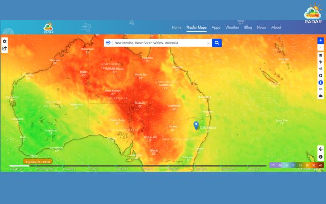
GoWeatherRadar provides high-precision forecasts
Ready to stay ahead of the storm? Check real-time weather and explore live interactive maps on GoWeatherRadar before your next adventure!
Sum up
Mastering a weather radar application is the ultimate way to safeguard every outdoor adventure and daily commute. By tracking real-time rainfall, severe storms, and sudden atmospheric shifts, you can make smarter, safer decisions wherever you go. Stay ahead of unpredictable weather conditions by checking live interactive radar maps on GoWeatherRadar before stepping outside!
◉ Processing: Connect a Software Defined Radio (SDR) or DSP to analyze signal timing (distance) and frequency shifts (Doppler effect for speed/direction).
◉ Visualization: Process reflectivity (dBZ) in software like Python or C++ and plot the data onto a geographic map.


0 Comments
Leave a Comment
Your email address will not be published. Required fields are marked *