Major Lake Tahoe Winter Storm Brings Up to 4 Feet of Snow and 80 MPH Winds
The Lake Tahoe winter storm is forecast to deliver several feet of snow across the Sierra Nevada, accompanied by powerful ridge-top winds and dangerous driving conditions. A Winter Storm Warning remains in effect from Wednesday morning through early Friday, with the heaviest impacts expected at higher elevations.
Lake Tahoe winter storm
Lake Tahoe Winter Storm: Key Updates
|
Winter Storm Warning |
4 a.m. Wednesday – 4 a.m. Friday |
|
Snow above 7,000 feet |
2–4 feet |
|
Snow near Lake Tahoe |
1–2 feet |
|
Peak snowfall rates |
2–4 inches per hour |
|
Ridge-top wind gusts |
Around 100–105 mph in exposed areas |
|
Most hazardous period |
Wednesday and Thursday |
How Much Snow Will the Lake Tahoe Winter Storm Bring?
A major winter system is heading toward the Greater Lake Tahoe region, bringing a combination of heavy snowfall, strong winds and sharply colder conditions.
According to the National Weather Service (NWS) in Reno, the Winter Storm Warning runs from 4 a.m. Wednesday, November 18, until 4 a.m. Friday, November 20.
Snow accumulation will depend largely on elevation.
Mountain areas above 7,000 feet could receive 2 to 4 feet of snow, while locations closer to Lake Tahoe's shoreline are forecast to see 1 to 2 feet.
The heaviest snowfall is expected across the higher Sierra Nevada terrain.
Wind is another major concern.
Gusts along exposed ridgelines could approach or exceed 100 mph, while communities around the lake may experience gusts of 30 to 40 mph.
Strong winds combined with fresh, powdery snow could reduce visibility and create localized whiteout conditions.
The NWS also expects snowfall rates of 2 to 4 inches per hour during the most intense periods from Wednesday into Thursday.
These conditions could make mountain roads particularly hazardous and disrupt outdoor activities.
The storm may also give California's ski industry a significant boost.
Several Tahoe-area resorts could receive substantial early-season snowfall, potentially making November the snowiest month before December at some resorts since 2010, according to the San Francisco Chronicle.
Palisades Tahoe has also moved its planned opening date to November 21.
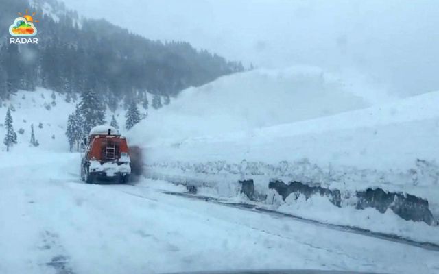
The NWS expects snowfall rates of 2 to 4 inches per hour (Photo: ABC News)
Check snow accumulation around South Lake Tahoe on RadarMap before heading outdoors.
Lake Tahoe Storm Timeline: Wednesday Through Friday
The strongest part of the system is expected to arrive early Wednesday, following increasing clouds and a chance of snow late Tuesday night.
Snow and strong winds will continue through Thursday before gradually easing on Friday.
Here's how conditions are expected to develop:
Wednesday, November 18
-
Widespread heavy snowfall develops across the Sierra Nevada.
-
Snowfall rates may reach 2–4 inches per hour.
-
Exposed ridges could experience wind gusts above 100 mph.
⬇️
Thursday, November 19
-
Snow and strong winds persist across the Lake Tahoe region.
-
Additional accumulation increases the risk of hazardous road conditions.
-
Blowing snow may further reduce visibility.
⬇️
Friday, November 20
-
Snowfall is expected to taper off during the morning.
-
Some lingering snow showers may remain possible.
-
Roads could stay snow-covered or icy even as the storm weakens.
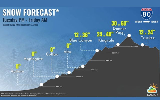
Snow forecast from Tuesday to Friday (Photo: NWS Sacramento)
Mountain Roads Face Major Disruptions as Snowfall Intensifies
The combination of deep snow, powerful winds and poor visibility could make driving across the Sierra Nevada extremely difficult. The NWS warns that travel may become very difficult or impossible, particularly on Wednesday and Thursday.
Several major routes are likely to face challenging conditions:
-
Interstate 80 (I-80): Heavy snow around Donner Summit could trigger chain requirements, traffic delays and temporary closures.
-
U.S. Highway 50 (US-50): Snow accumulation and reduced visibility may disrupt travel between Sacramento and South Lake Tahoe.
-
State Route 88 (SR-88): Snow-covered pavement and slippery mountain sections could create additional hazards for drivers.
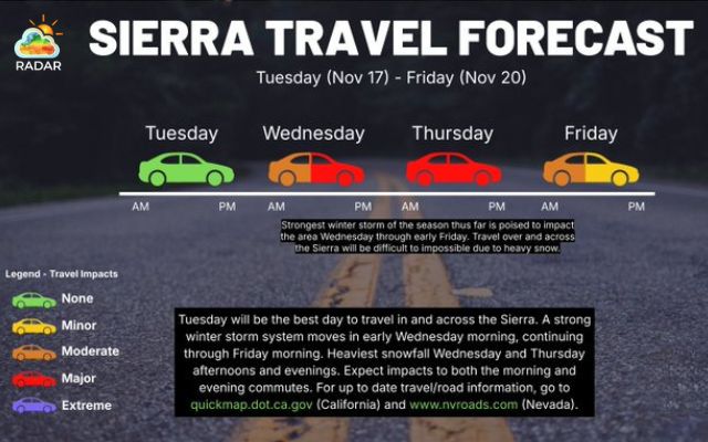
Major travel impacts from Wednesday through Friday (Photo: NWS Reno)
Winter Storm Safety Tips for Travelers
-
Check road conditions: Review Caltrans QuickMap for closures, traffic incidents and chain requirements before departure.
-
Carry tire chains: Make sure your vehicle has the appropriate chains and that you know how to use them.
-
Prepare emergency supplies: Pack warm clothing, drinking water, food, a flashlight and a fully charged phone.
-
Limit mountain travel: Avoid unnecessary trips during the heaviest snowfall, especially Wednesday and Thursday.
-
Drive cautiously: Reduce speed, leave extra space between vehicles and avoid sudden braking on icy roads.
The incoming snowfall could improve early-season conditions for ski resorts, but it also brings considerable risks for residents and visitors.
Monitoring official weather alerts, radar activity and road updates will be essential throughout the storm.
References
-
ABC7 News
-
Powder.com
-
Mercury News
-
San Francisco Chronicle




0 Comments
Leave a Comment
Your email address will not be published. Required fields are marked *